Ilha de Moçambique: the island the country left

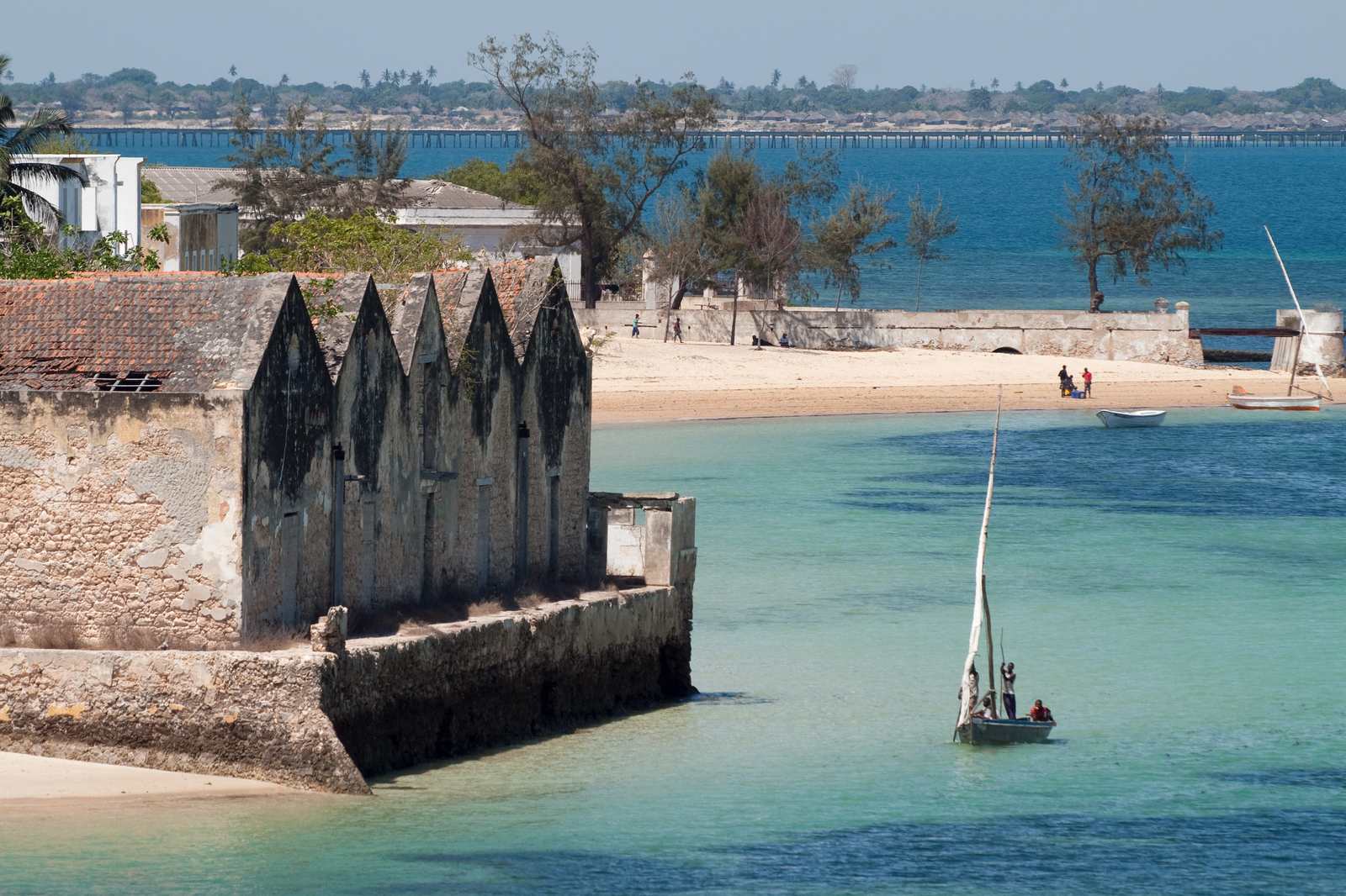

Mozambique is named after an island that used to be the colonial capital, and the island declined to become a museum.
I have not been to Ilha de Moçambique, the Island of Mozambique. I have been reading about it, walking the same sentence until it started to feel like weather. The country is named after this place, and then the colonial capital function moved south. What the notes keep returning, the ones I trust enough to put on a list, is a working fishing town in crumbling coral stone. Planned streets in the north. Palm thatch in the south. Lateen-rigged dhows. People who did not leave.
That last clause is the part I would defend to someone who had already booked Maputo. Maputo has the ministries, and the argument about the future. Ilha de Moçambique has the name. Plenty of countries would have turned the namesake into a caption under a flag. The claim I cannot drop is that this island kept ordinary work.
The pin on the wishlist sits at about 15 degrees south, 40.7 east, in Nampula Province, which is enough geography to know you are looking at the north of the country and not enough to pretend I know the road. Northern Mozambique, on a map, is a long attention span. The island is a comma in that sentence. The comma is doing more work than the name on the cover.
How the name travelled is a story I will not freeze. The reading keeps offering a local ruler whose name the Portuguese rendered into something like Moçambique, then offering three spellings and a shrug. I’m not picking a spelling. What I will stand on is the simpler, ruder fact: the island had a name before the country did, and the country took it, and then the colonial capital function moved south. Independent Mozambique has always been run from Maputo. “Left” was the verb on my list. I mean it in the administrative sense, and only of the colony. People did not leave. People are the whole point.
A colonial capital that stops being a capital usually has two afterlives, and both of them are slightly embarrassing. It becomes a shrine to itself, or it becomes a town that has to remember it used to matter. Ilha de Moçambique, if the photographs and the stubborn sentence are telling the truth, took a third option. It went on putting boats in the water.
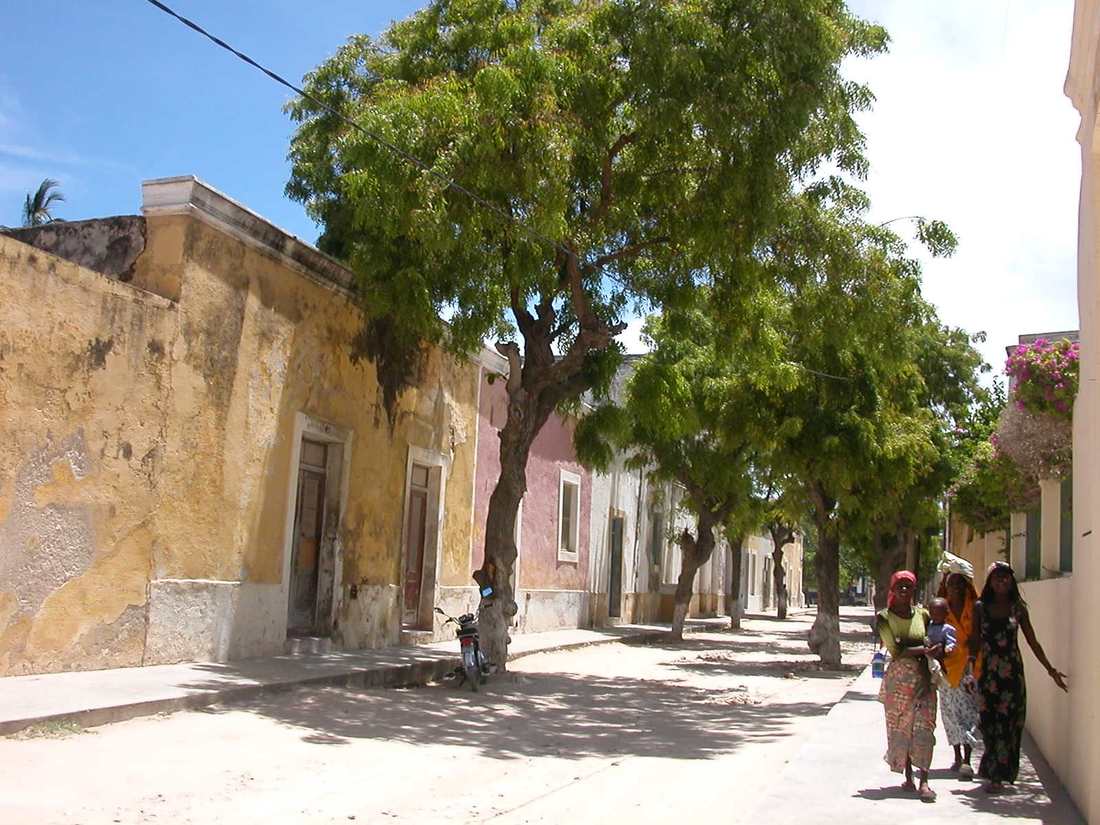

The coral-stone is the part that makes the island specific. Coral, cut and stacked along planned streets, now crumbling in the way stone crumbles when salt has had a long time to think. I have not put a hand on it. I keep opening pictures of facades that look load-bearing and tired in the same hour, lime and shadow, a doorway that still has a job because someone lives behind it. Planned streets are a colonial habit. Streets that still have washing in them are a town. The photographs also show gaps: unused rooms, ruined walls, the look of a quarter that holds more monument than household. That is part of the truth too.
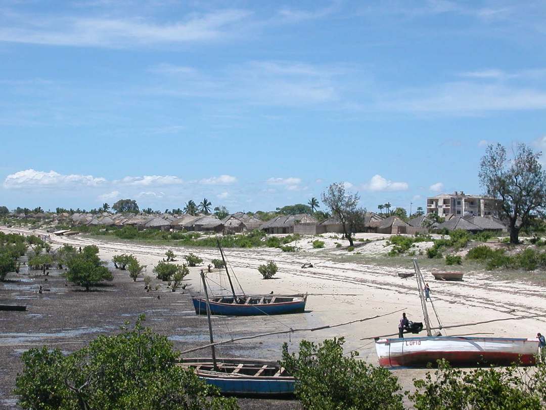
The reading splits the island in two, and the split is the first piece of vocabulary that felt like a receipt. Cidade de pedra e cal, the stone-and-lime town, is the northern fabric: the streets that look like an administration used to walk them, the monuments, a smaller population, buildings that sit empty. South of that, in the notes, the houses change their roof. Cidade de macuti, macuti town, palm-leaf thatch, is the word the other half wears, and it is the dense one, overcrowded and poor, where most people live. I’m treating both names as provisional until someone who lives there confirms they still say them that way. I’m also treating the split as the thing that keeps the island from collapsing into a single mood. Stone is what the cameras already know how to want. Thatch is what tells you the island did not empty when the clerks left.

I’m not inventing a single year for when the capital function moved. UNESCO’s own timeline says 1898, to Lourenço Marques, later Maputo. Britannica has the island as capital until 1898 and the colonial government transferred by 1907. A University of Porto paper distinguishes an 1898 governor’s circular from a 1907 legal reorganization. That conflict is why a clean date would be a fake. The sequence I trust is only this: island as the reason for the country’s name, island as a former colonial seat of power, island as a place that still has to eat.
“Former seat of power” is the phrase that ruins places if you let it. It licenses the visitor to look at other people’s houses as exhibits. The angle I’m defending is the opposite of that license. If Ilha de Moçambique is still a fishing town, then the crumbling is weather. It is not the main character. The planned streets are where some people still walk to buy something, and where some walls have stopped being anyone’s. The old capital is not one neighbourhood that missed a memo. Most of the living is south of the lime.
The island is small enough that distance is still a person’s distance. I like that as a scale claim. A bridge has joined it to the mainland since the 1960s; one account dates the crossing to 1967. Vehicles use it. Motorbikes show up in the accounts I have read. I have not counted them. If someone writes to say the traffic is louder than the sentence allows, I will believe them. The sentence is a wish about scale. The bridge is the fact.
The boats I’m less willing to give up. A dhow, the lateen-rigged fishing boat of this coast, is the object the list will not stop putting on the water. I have not watched one leave. I have looked at enough photographs of lateen sails off this shoreline to know what I’m hungry for, which is not the same as having stood in the hour. Dawn is doing too much work if I pin the boats to it. I know that. Dawn is what you write when you have not been handed the actual clock. What I mean is the working hour. Nets. A hull that has to come back. The island facing the water because that is the job. A brochure did not tell it to.
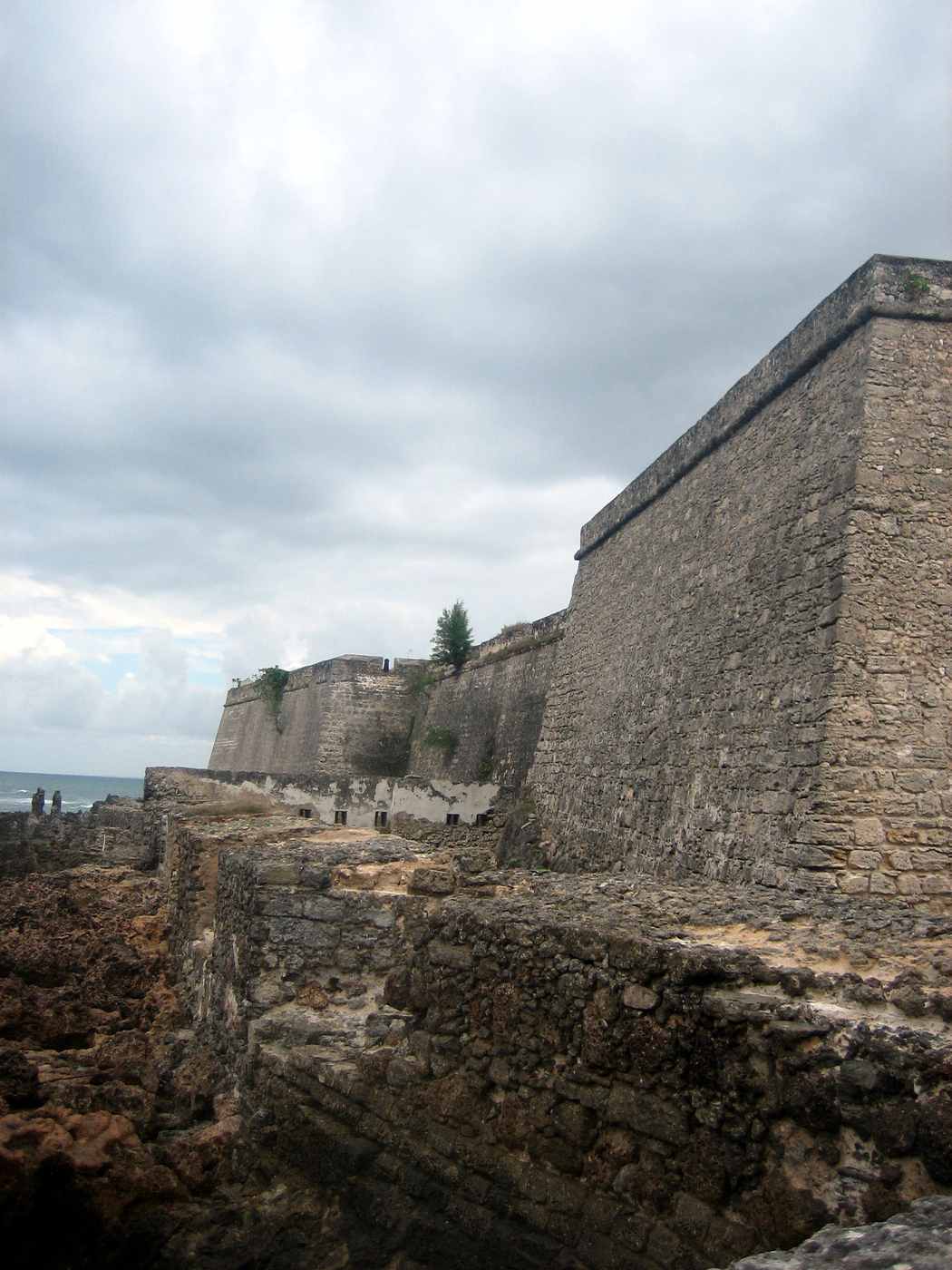

There is a fortress whose name is Fortaleza de São Sebastião, St. Sebastian, built from 1558 to 1620, and a chapel, Nossa Senhora de Baluarte, Our Lady of the Ramparts, dated 1522, which people like to call the oldest European building in the southern hemisphere. That superlative lives in guidebooks. The 1991 listing and Britannica date the chapel without crowning it. A UNESCO rehabilitation booklet only says it is thought to be the oldest Portuguese building in the southern hemisphere. I will not repeat the crown as fact. Superlatives are how a neighbourhood gets talked into being a site. I want the site to lose. I want the neighbourhood to win the paragraph. The fort is there the way a former office building is there: large, hard to ignore, no longer the reason anyone cooks dinner.
UNESCO lives in the same drawer, and the plaque exists. The island was listed as a World Heritage place in 1991, under criteria (iv) and (vi). Heritage listing is a double-edged tool on an island like this. It can keep the coral from being sold off. It can also teach visitors to see the living as custodians of a look. My opinion, which is all this piece can really spend, is that Ilha de Moçambique is more valuable as a town that happens to be built of coral than as coral that happens to contain a town.
Zanzibar has a Stone Town, and that is the Stone Town the internet already trained itself to mean. I mention it once, as a warning to myself. The other one is famous for being famous. This one lent a country a name and then kept fishing. If you go looking for the Swahili-coast cousin of a place you already know, you will miss the weirder fact, which is that Mozambique’s namesake is still a street some people live on, and a roof most of them sleep under south of the lime.
I keep trying to picture what the leftover life actually requires. A former governor’s house with a family in it, or a former governor’s house with no one in it. A wall that used to mean a boundary and now means shade. A market that does not care what the island used to administer. I can construct that picture from photographs and from other towns I have only read about, which is a way of saying I can construct it wrong. The cost of this essay is that I cannot tell you whether the crumbling is scenery from the inside or just damp. I cannot tell you what the streets smell like when the boats come in. I can tell you that the wanting attached itself to a political fact (a name, a colonial departure) and then refused to stay there. It slid toward the smaller claim: that a capital can lose the file and keep the kitchen, even if the kitchen and the monuments are no longer the same few blocks.
Someone who lives on Ilha de Moçambique would have a different essay, and they should. They would have the hour, the language in the doorway, the repair that did not hold in the last wet season. Mine is the armchair version, which is allowed to be obsessive and is not allowed to be scenic by theft. I have not stood in those streets. A dhow scrape is a sound I have only imagined. I have not learned whether macuti is still the word a person uses for their own roof, or only the word the papers use for a district.
The limit is that one, and it is not a small one. Everything here is a position taken from a distance. The distance is the genre. I wanted a place where the country’s title page and its leftover life were the same few streets, and I found, on a list, an island doing a version of that without asking to be congratulated, monuments in one half and the denser life in the other. If I ever cross the bridge, I want the working hour, and I want to be corrected by it. I want the name to shrink to a sign, and the town to take up the rest of the day.
The facts
Ilha de Moçambique, the Island of Mozambique, sits off the coast of Nampula Province in northern Mozambique, about four kilometres offshore. The pin I have is roughly 15.03° S, 40.74° E. A bridge built in the 1960s (Britannica dates it to 1967) is the ordinary way on. Boats and dhows work the water and take side trips; they are not the default land access. Nampula (APL) and Nacala sit on the northern mainland as airports; Lumbo is a nearby airstrip. I will not name one of those as the gateway. Former colonial capital. World Heritage site since 1991. Working fishing town.
Sources
- Photo: Stig Nygaard, CC BY 2.0 · img/hero.jpg
- Photo: Lazare Eloundou Assomo, CC BY-SA 3.0 IGO · img/stone-street.jpg
- Photo: Lazare Eloundou Assomo, CC BY-SA 3.0 IGO · img/macuti-town.jpg
- Photo: Erik Cleves Kristensen, CC BY 2.0 · img/fort-sao-sebastiao.jpg
- https://www.indexmundi.com/mozambique/country_name.html
- https://en.wikipedia.org/wiki/Mozambique
- https://en.wiktionary.org/wiki/Mozambique
- https://whc.unesco.org/en/list/599/
- https://www.britannica.com/place/Island-of-Mozambique
- https://www.britannica.com/place/Maputo
- https://whc.unesco.org/document/104519
- https://ojs.letras.up.pt/index.php/AfricanaStudia/article/download/7290/6679
- https://repositorio.iscte-iul.pt/bitstream/10071/11570/1/Eduardo%20Medeiros.pdf?locale=pt_PT
- https://oxfordre.com/africanhistory/display/10.1093/acrefore/9780190277734.001.0001/acrefore-9780190277734-e-808
- https://en.wikipedia.org/wiki/History_of_Maputo
- http://whc.unesco.org/document/168031
- https://en.wikipedia.org/wiki/Mozambique_Island
- https://en.wikipedia.org/wiki/Mozambique_Island_Bridge
- https://www.businessday.co.za/bd/life/2024-09-04-tides-of-change-on-mozambiques-ancient-island-capital/
- https://culturalheritageonline.com/magazine/unesco-world-heritage-sites-near-island-of-mozambique/
- https://courier.unesco.org/en/articles/saving-urban-landscapes-island-mozambique
- https://hdl.handle.net/10216/152621
- https://www.monumentos.gov.pt/SITE/APP_PagesUser/SIPA.aspx?id=27890
- https://www.telegraph.co.uk/travel/destinations/africa/mozambique/articles/paradise-island-that-time-forgot-ilha-de-mozambique/
- https://pt.wikipedia.org/wiki/Capela_de_Nossa_Senhora_do_Baluarte
- http://whc.unesco.org/archive/advisory_body_evaluation/599.pdf
- https://www.lca.logcluster.org/226-mozambique-nampula-international-airport
- https://dlca.logcluster.org/print-preview/4464
- https://dlca.logcluster.org/print-preview-current-section/4775
- https://en.wikipedia.org/wiki/List_of_airports_in_Mozambique